
This area of the national forest lies along the border with West Virginia. Schloss is the German word for castle, a descriptive name given to the large rock outcroppings for which this area is best known. There are many trails in the area other than those listed below, with numerous opportunities for long circuits.
| Little Schloss |
Location: about 7 miles west of Woodstock
Picture: looking northeast from Little Schloss
Description: A pleasant trail away from the crowds, the highlight is a large rock outcropping with a very good view. A short side trip will take you to the top of some cliffs, also with a good view.
Notes:
last hiked: 2001
| Big Schloss |
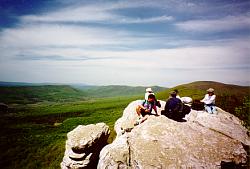
Location: about 8 miles west of Woodstock
Picture: Lunch on top of Big Schloss.
Details: more information available here.
Description: Big Schloss is possibly the most impressive rock outcrop found in the nearby mountains. The views from on top are excellent and this is also a good area for viewing wildflowers in the spring.
Notes: This is a well known trail and thus gets heavy use on weekends.
last hiked: 2000
 Just southwest of Front Royal, this is the portion of the
GW National Forest closest to the DC area. Fort Valley lies between
East and West Massanutten Mountains, running north-south for about 25 miles.
The north entrance, going through a narrow gorge created by Passage Creek,
is one of the most
scenic few miles of road anywhere in Northern Virginia. Although heavily
used by fishermen and local campers, this area doesn't get nearly as many
hikers as the nearby Shenandoah National Park.
Just southwest of Front Royal, this is the portion of the
GW National Forest closest to the DC area. Fort Valley lies between
East and West Massanutten Mountains, running north-south for about 25 miles.
The north entrance, going through a narrow gorge created by Passage Creek,
is one of the most
scenic few miles of road anywhere in Northern Virginia. Although heavily
used by fishermen and local campers, this area doesn't get nearly as many
hikers as the nearby Shenandoah National Park.
The hikes are listed in order from north to south. A single road runs down the center of the valley, so it's hard to get lost.
Above is a picture of Passage Creek, taken at the Elizabeth Furnace picnic area.
| Buzzard Rock |

Location: North end of valley at the Elizabeth Furnace picnic area (or near the Fish Hatchery for northern access)
Picture: Appropriately enough, a buzzard (turkey vulture) soaring over Buzzard Rock.
Description: Buzzard Rock is an outcropping of steeply tilted rocks which proved a very nice overlook of the Passage Creek gorge. North of Buzzard Rock is an overlook looking north; to the south are several overlooks looking east over the Shenandoah River (South Fork) to the Blue Ridge.
Notes: The Elizabeth Furnace picnic area has 2 short historic trails with markers discussing the making of pig iron in this area during the 19th century (unfortunately, many of these markers had fallen into disrepair the last time I was there).
last hiked: 2002
| Signal Knob |
Location: North end of valley, near Elizabeth Furnace picnic area
Details: more information available here.
Description: Signal Knob got its name from having been used as a lookout and signaling point by the Confederate army. It provides a very good view to the north and west. The trail also has 2 nice viewpoints looking east into the north end of Fort Valley.
Notes: This is just about the only dayhike in the area which might get crowded on weekends.
last hiked: 1998
| Veach Gap |
Location: Just north of Seven Fountains (about 10 miles south of north entrance to valley)
Description: Follow a creek through a small gorge and into a pleasant hemlock forest. Then climb to the ridge of Massanutten Mountain for some views to the east. You will be able to see the north end of Shenandoah National Park and will be looking almost straight down on the south fork of the Shenandoah River. To make a loop, you need to bushwhack along the ridge for 1.5 miles. The summit of Little Crease Mountain, one mile to the north, is a pleasant spot but provides only very limited obstructed views.
Notes: I have not personally done the bushwhack section of this loop, so I can't comment on it.
last hiked: 2002
| Kennedy Peak |
Location: South end of valley, may also be approached via Luray. Start circuit at Camp Roosevelt.
Details: more information available here.
Description: A nice hike through the forest and then along the ridge of Massanutten Mountain. The highlight is a 360 degree view from a wooden platform atop a stone shelter. Also passes the remains of some pit and trench mines where iron ore was once extracted.
Notes: To the tower and back is only 0.5/100 from an upper parking area. This section of trail is heavily used.
last hiked: 2002
| Duncan Knob |

Location: South end of valley. Camp Roosevelt may be accessed via Luray, Crisman Hollow Road from New Market Gap.
Picture: View from Duncan Knob
Description: The highlight of this trip are the excellent views from on top of Duncan Knob, and the rock scramble to get there.
Notes:
last hiked: 2005
Return to Northern Virginia Dayhikes